19 - 29th March, 2019
The following blog was written for and published in edition #114 of Western 4W Driver magazine:
western4wdriver.com.au/
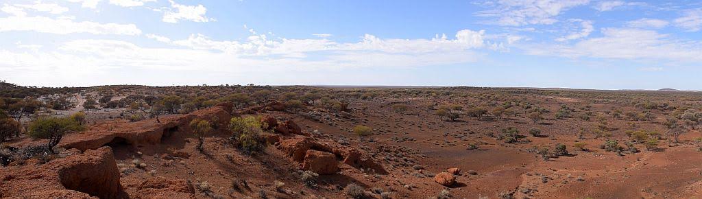
With the sting of summer’s tail now behind us, now is the time for planning trips to the north and inland. This is a story of a geocaching adventure I took with my travel buddy, Warren, through the Mid-West and the Gascoyne. It was March, the wildflowers had gone, but so too had the tourists. I probably do not need to mention the flies. May to September is the best time for this region. Our primary goal was the Kennedy Ranges and Mt Augustus, with a personal milestone to complete on the way.
Our first camp was made inland of Geraldton at Ellendale pool. A picturesque place you must visit. I had left two caches behind the last time I was here, so upon arrival, I proceeded to get my name in the other logbooks. The first one could not to be found and I had little confidence in finding the second. A short walk from the camp and some ferreting around in the bush and I had found another, the second for the trip.
In the middle of the night I was woken by an animal of some sort running into my camp table. In the morning, a look of horror washed over my face …. there was only one shoe outside the swag! The noise I had heard earlier was a fox, making off with my sandal. This would be funny if I had brought a spare pair of shoes with me. Packing up with one foot in the gravel wasn’t much fun and we had to change our plans. Geraldton was now our first destination - for another pair of shoes. The Philosophy of “if it hasn’t got 2 uses, you don’t take it” doesn’t apply to shoes.
Missing a sandle:

It must have been a hilarious sight, me walking through the main street of town, sandal on one foot, nothing on the other. Warren deliberately followed quite a few steps behind. Inside the shopping center, I spied Best and less and had a win better than lotto. A $2 pair of thongs. The girl behind the counter in throws of laughter as I recounted my story of a dirty little fox and a sandal that had gone AWOL. But like a comfortable pair of old boots, I couldn’t let my one sandal go, so it was sandal on my left and thong on my right….for a while anyhow. I may as well milk it for all its worth.
Now on the coast, we decided on heading to Carnarvon before turning east for the Kennedy’s. We dropped into the Gladstone campground, but decided to give the limestone dust bowl a miss for a much nicer place just up the road. Wooramel River retreat, a fantastic station stay, even without any water in the river. It was a hot day, so we spent the remainder of the afternoon sitting in the shade of the numerous river gums with a refreshing ale as we watched the sun go down and the full moon come up.
Wooramel River retreat:

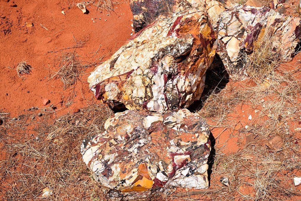
Arriving at the mookaite mine:

Mookaite mine:

Mookaite:
Mooka Spring:


There is a shack nearby, along with some heavy machinery. Obviously, it’s too hot to mine here at present, so the machinery and hut are in care and maintenance mode until the weather cools down a little.


If we would have found some shade by the water, we would have camped here the night, however, today is very hot, in excess of 40 degrees and its only lunchtime. We decide to push further north for Yenny Spring. It is slow going up the coarse stony track, with its numerous washouts that cut the track in numerous places. We arrive at most remarkable place, Yenny Spring. It’s too early to set up camp and too hot to stop, so after a quick explore on foot we drive further north, past Venny Peak and onwards a bit longer. The track gets a lot rougher past here and the washouts are getting deeper and more numerous. We decide not to continue into the unknown and double back for Yenny Spring.
Venny Peak:

Parking in the shade of a patch of river gums, we do something a bit different and spend the rest of the afternoon cooling off with a relaxing ale. There is a trickle of water in the creek here, but it’s got nothing on Mookah Spring. A place where stock was once staged, we find some old troughs and a small spring, fenced off with old wooden posts and wire. The spring is a very small hole, full of vegetation. We are surprised when we test it for depth. A tree branch, 3 meters long doesn’t touch the bottom. If the vegetation was removed, it would be a splendid water source and more than likely, permanent.
Yenny Spring:


We watch as the full moon crests the southern side of the range whilst we cook dinner, the temperature now rather pleasant and the annoying flies have gone to bed for another day. Lying in the swag, I hear old mate dingo, off in the distance, howling from different parts of the range, obviously on the prowl in the light of the full moon. I now worry about my newly acquired $2 thong and my old comfortable sandal. I’m still milking the situation for all it’s worth:

Around 5am, I am woken by the blood curdling howl of old mate, still on the prowl. He is very close by. I note my shoes are still where I left them. With the dawning of the sun, comes the heat and the flies. We find the spring has overflowed during the night and the runoff is now making its way down to the creek. Breakfast done, we hit the track south for the highway to go explore the eastern side of the range.
From Gascoyne junction, we make the 50 odd kilometres to the eastern side and whilst cloud is forming in the sky, it’s still hot as hell. We hear on the radio, tropical cyclone Veronica, a category 4 low, is going to cross the coast to the north in a day or so. We start worry about the remainder of our trip out here as its no place to be when it’s wet.

Arriving at the East Kennedy's


We try to find some shelter in the minimal shade to be found at the campground. There is only one other camper here and he drops by for a chat. I ask if he knew what geocaching was about and he didn’t have a clue. I said I would show him what it was all about around 6pm, when it would be a bit cooler. We start off down the escarpment trail, on the understanding that daylight will be my issue departing this late in the day. Part way up the trail, the GPS points due north to the cache, only some 250 meters away. But the route is a very steep scree slope. I ponder the shortcut. If I can climb this slope, I will cut a couple of kilometres off my journey. It’s very steep, loose and somewhat dangerous. If there is a hard way to a cache, you can be sure I will find it. I make the decision to climb whilst our new found friend stays behind on the trail. The further I climb, the more I know I have made a bad decision. I am struggling to ascend this slope and my $2 thong is giving me grief: the sole of my foot is sweating profusely, and the thong and foot are constantly parting company. I should have put on 2 sandals at least.
A hard, silly climb:

Going up is the easy bit. The further up I go, the more difficult and dangerous it will be to come down. The GPS is egging me on. Down to 180 meters, then 150. Eventually after a lot of climbing, down to 100. I get to the top of the range, and there is a large prominent knob on top. The cache is still some 60 odd meters away, at the top of this knob, and I have no way to climb the vertical face I am presented with. All that work for nothing. The disappointment of having to log a did not find was a heavy load to bear after all the effort I had just put in. Mind you, the scenery was stunning.
Yep, its on top of that
un-climbable knob:


What’s worse, the more adventurous challenge of getting back down without breaking my neck was yet to come. The single plugger gave me more grief on the way down, constantly pulling the plug through the base, and the slip sliding of a sweaty foot on slippery rubber just compounded the problem. The terrain was intense to descend, but slowly and surely, I caught back up with my new friend, to make the short trek back to camp just before dark. Unfortunately I had no cache to show him. But I had gained knowledge on the stupidity of taking such a route in a two dollar thong.
Camped at the Kennedy's

The next morning, TC Veronica had made her presence felt. Although it was still warm, it was very dark and threatening and the wind ever increasing. It was due to hit Karratha, some 470Km’s away sometime today. With this in mind we headed for Mt Augustus, stopping to check potential camp spots by the Lyon’s river. Coming at the end of summer, the Lyon’s river disappointed with its lack of water. The scenery made up for it though, mounts such as Mt Phillips, providing small, isolated bumps in an otherwise flat landscape. From Cobra Station It is a short trip to the mountain where you drive parallel to the inselberg providing spectacular views. Cattle pool prior to the caravan park is a must see, though it was nothing like I had seen 6 months prior. Summer hadn’t been kind to the water sources out here.
Arriving at the mountain, we almost had the place to ourselves, with only one other here. We elected to set the swags up under the camp kitchen roof due to the wind and the risk of overnight rain – which didn’t eventuate. There are 3 geocaches located here, one I had found previously on the Kotka Gorge track. An earth cache and a traditional at the summit would have to wait for better weather conditions.
Mt Augustus :


The next morning with the wind howling, we left Mt Augustus without seeing anything so we could put as much distance between us and TC Veronica as we could. The Landor-Mt Augustus road is a part of the Kingsford Smith mail run – one of several tourist pathway’s in the region. A Gnamma hole with petroglyph’s can be found not too far south of the mountain.
Gnamma hole:

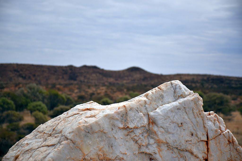
Heading further south we find on our maps a marked location for an old homestead well. We stopped to investigate. A derelict bore and signs of old cattle workings were to be found. Here I noticed a Mt James homestead to the west. Not knowing if it was a working station or abandoned, we went in for a look and were rewarded handsomely. The Homestead was abandoned and in quite reasonable shape. Evidence of prior occupation littered the landscape. Nestled on a plain surrounded by ranges, a large quartz blow rose out of plain a few hundred meters west of the homestead. It was a great little find and we spent a good while taking photographs and imagining the harsh existence one would have had trying to make a living off the land.
Mt James Homestead:


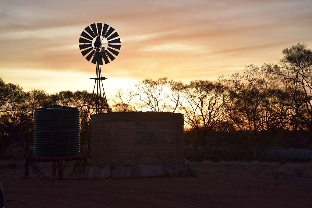
We continued south before arriving at the Mt Gould lockup for the night. Still windy and quite warm we had dodged a bullet. Veronica didn’t cross the coast and blew herself out. There was a remarkable sunset tonight with the cloud starting to break up. Lucky for me, there just so happens to be a geocache here and I had its log signed in no time.
Mt Gould and lockup:


The next morning, the wind had dropped off. Heading south, we crossed the 26th parallel and arrived in Meekatharra for some fuel. Warren had to replace his butane stove which had partially failed, and of course, another cache at the town lookout had to be found before we left. With the weather once again warming up and no evidence of a cyclone anymore the plan was to head West at Cue for Big Bell and Walga Rock, both places a must visit if in the area. On the way we stopped in at lake Nallan to pick up a cache at an old railway overpass and another detour to check out the graves at Milly Soak.
Milly Soak:


Lake Nallan:

I suggested we set up camp early today at Afghan Rock and we can do Big Bell the following morning. An early afternoon camp, with a cold beverage in the shade at the rock was hard to pass up. Climbing the rock to watch the sun go down was very worthwhile too.
Afghan Rock:


Big Bell Hotel:


We moved on down to Walga Rock. If you want to see some serious indigenous art, you have to come and check this place out. There is so much here to see, but please respect the indigenous heritage and stay behind the barrier. Treat it with respect so we get continued permission to visit. After Walga, we had to visit one other place that is essential to see – the Dalaranga meteorite crater. I jest. Wolfe Creek it is not.
Walga Rock:


Onto Mt. Magnet, we set up a quiet camp in the breakaways around lennonville. That night, planning our last few of days I suggested we camp at Warriedar and nearby by the old Rothsay mine for our last night.
Mt Magnet camp:


In the morning I knocked off another cache at the granites just to the north of Mt. Magnet and we headed to Yalgoo for another couple. Checking out all Yalgoo had to offer, we stopped at Jokers Tunnel, where I again had to scale another tricky rocky face, only to have to search for some time to get my name in another logbook.
Yalgoo:


The view above Jokers Tunnel:

We made our way to Warriedar and was mighty impressed with the restoration work Trackcare WA had done so far on the homestead. Again, it was blistering hot and with the volume of flying sultana’s in the air, all we could do was to relax with a cold bevvie (and a fly net) in the shade of the veranda until the sun went down. Something different I guess.
Warriedar:


The following morning, as we shot off towards Paynes Find for some fuel, we found a most remarkable old shack a couple of kilometres to the North of the homestead. We contemplated what stories this structure may hold:
Old shack on Warriedar station:

The road to Paynes Find was in great condition. A picturesque drive around and across Mongers lake and through Auiferous bearing ranges. The road lined with many Kurrajong trees. Hoping to visit the battery ay Paynes Find, we were disappointed to discover on arrival it is open only in the wildflower season (August to October). But all was not lost, because within a few minutes, I struck gold of my own. Another geocache. A little tricky to find, but I had the log signed without too much effort.
Fuelled up again, we hit the highway South before turning west once again towards Perenjori. On arrival at Camel Soak, I had added another 6 geocaching smilies to my tally for the day. We made our way into the Karara rangelands and took the 4wd track out to Rothsay. Unfortunately, as it now stands, mining has restarted operations here with the inappropriate “keep out - active mining area” signs in place. That means I will have to revisit Rothsay another time. Which is a little disappointing, but I need to explore the Karara rangelands in greater detail sometime in the future.

With a planned camp at Rothsay now out of the question, we needed an alternative. Visiting the Sir John Forrest lookout in the Damperwah Hills, we had found what we were looking for. One being a place to camp for the night, the second being a special place to celebrate my personal milestone I will achieve before I return home - Exceeding 100,000Km’s of gps logged trips away. I couldn’t think of a more fitting place than one that bears Forrest’s name. WA owes a great deal to this man, for his services to exploration, surveying and politics - being the first Premier of this great state from 1890 to 1901.
Ascending the lookout on foot, tools and booty in hand, I laid an unofficial, geocache type hide atop the summit to celebrate my 100K milestone. I had a special coin, known as a pathtag minted. Unfortunately, it hadn’t arrived from the US In time for this trip, but in this hide I have left one of my signature pathtags and details on how to obtain my special 100K one that was especially made for the occasion. This was placed in March 2019 and to the best of my knowledge, has not been found by year end. So, as readers of this fine magazine, I share the coordinates with you. First to find wins the prize:
John Forrest Lookout:

The Location of the prize:


You will need to navigate your way to S29 18.552 E116 43.832 for this celebratory pathtag, and there is only the one set on offer. The great mate Warren is, he brought up cold beer to the summit. When the job was done, He congratulated me on my milestone and I thanked him for his companionship over many thousands of those kilometres over a nice cool one. I had a swig for Forrest too.
In the morning, we headed for home. 3300Km’s traversed over 11 days and a personal milestone accomplished. The Midwest and the Gascoyne has so much to offer. Now is the time to get your map books out to plan for that winter getaway to the region. I guarantee you will find treasure out there. Cache on.
Trip Stats:
10 nights under canvas
3339km travelled
390L fuel used
trip average of 11.7L/100
(worst 12.7, best 9.7)
cost of fuel $598
Camp fees total $31
Wooramel $13
Kennedy Range $8
Mt Augustus $10
With an over nighter to Collie and a 4 night prospecting trip (both not blogged), the yearly tally stands at 21 nights under canvas.
Trip Vids:
Such a big trip means lots of video -
No comments:
Post a Comment