Wednesday 5 December 2018

Nippley on the Nippon

August 17 - 23rd


Although I had been out in the Great Victoria Desert twice on my last trips, the weather was perfect for yet another one. Finishing work at 1100 on the Friday, I rushed home to complete the final packing and hit the road early Friday afternoon. The plan was to meet my work mate, Len out at Mundaring around 1400, then head East for a few hours and pull up somewhere unplanned before dark. That would at least get us a few hundred Km's closer to the desert.

We got as far as Burracoppin before the sun was going down. Spying a nature reserve on my maps, we headed South and had a scout around. Unfortunately, there was nothing suitable there, however we did find a large gravel pit and pulled up stumps for the night. I love gravel pits (when it's dry, anyway), they make a great place for a quick overnight stop.


So it had been a long day for me, having started work at 0500. With a nice little fire going, dinner done and a glass or two of red, it was time for bed. Tomorrow would be a big day, traversing unknown routes and not even sure if we could get through my planned, unknown tracks. Time will tell I guess.

Waking before sun up, it was a cold morning. The awning had a nice coating of ice on the underside. With breakfast and coffee done, we hit the road for Kalgoorlie, the start of our trek into the GVD.


Even by the time we had hit kal, I was behind schedule to what I had planned to achieve. We pushed on, up unknown roads for my planned camp. However some 50Km's short of where I had planned to camp, I found an abandoned homestead on my maps. I suggested to Len that we should go in for a look. If it had a suitable clearing and timber, we should try to utilise it, because where I had planned to camp was an unknown venture. A short trek down the station track and I was delighted. Old homestead ruins, timber everywhere and lots of cleared ground. We had found the perfect camp for the night.


Interestingly, what I saw in the distance that I thought was a raised pad for a building of some description, was actually once a swimming pool. What a stunning find that was:


We managed a reasonable distance for the day and had an enjoyable night by the bush telly. 


The next morning the fun would begin. Trying to see if we could navigate this country and it's unknown tracks into the desert. It didn't take long, some 30Km's up the road we were thwarted by what now is a large mining operation. All my tracks led into the minesite all with 'authorised entry" signs. I was about to go into the site office to ask for alternative routes, when I decided to back track a little to see if we could find a track heading East. And that I did, a feint track that we followed led us around the Southern boundary of the mine site and got us onto the Nippon Highway, a highway by name, not stature.


Whilst it was a slow track, we were making progress. From this point on, I was concerned our passage through to Laverton may just give us some drama's. The Donkey track we were on turned into a super highway. Now whilst there was no signage at all, this had to be a "private" haul road. How dare they: Consume crown land and pastoral lease roads into private entities. So with no other option, or signage telling us to keep out, we hit the super highway.

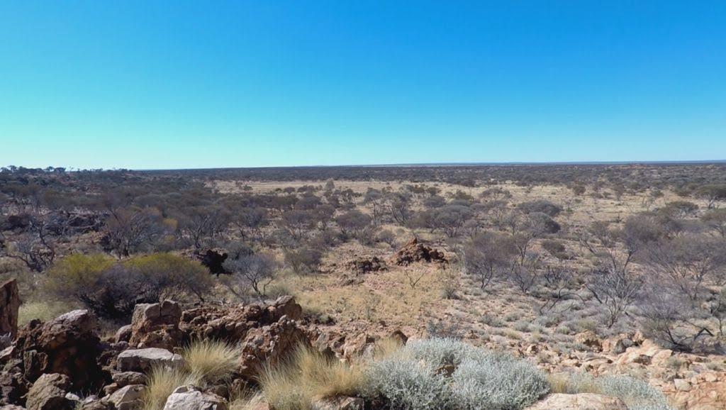
20 odd Kilometres down, with no sign of haul trucks or other mining traffic, the superhighway veered North East of the Nippon highway. We were now on unplotted ground according to the map. I noted a track a bit further on that looked like we would cross. This would then take us down to the Nippon again. So we turned South at the track junction and found mulga and spinifex. We had hit the desert.

A short journey down this track and we re-joined the Nippon, unsure of what the track conditions would be like. Well it turns out, it was bloody fantastic. Typical for most tracks you see making their way through desert country. Some large swathes of burnt out country gave a different perspective of the landscape. Interestingly though, the highway seemed to end at a T junction not marked on my map. So we turned East and still appeared to be on the Nippon. It would be easy to lose ones way if coming from the other direction. Making the turn off for Queen Victoria Springs (A life saver for Ernest Giles after crossing the desert in 1875, after 17 days without water), we decided to have lunch.


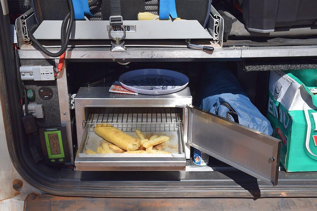
And what a place to have chicko rolls and chips for lunch!


Queen Victoria Springs has always been on my bucket list. Not this trip however, we have too much other ground to cover. From here I was worried, haul roads, baseline roads and other unknown entities marked on our maps were in our path. Falling behind time, and worried about the scale of vegetation over the tracks, I decided to give lake Minigwal a miss this time around and make direct line for Plumridge Lakes.

A good decision this turned out to be too. Apart form some slight navigation decisions to make, it was pretty uneventful. The surrounding country side very reminiscent of the Anne Beadell Highway, East of Neales junction.

Hitting the Plumridge lakes Nature Reserve boundary, the vegetation immediately started to close in. Nothing drastic, but nothing like we had seen so far either. About 20Km's from Salt Creek Junction, I whizzed past what I thought to be a nice little clearing. Turning back, we were again rewarded with an ideal desert camp site for the night.


The mornings were getting warmer now and we were getting into the swing of life on the road in the desert.


Unfortunately for Len, he discovered he had a flat tyre. At least it wasn't me this time. It took us a bit to actually find the hole, such was the minuscule sidewall stake, but find it we did, and now being plugged up we hit the track again but not until 1000. So a late start today:


It didn't take long to be stuck behind a ship of the desert. After about 3km, we just pulled up for a bit to let him go. Unfortunately, after we took off again,we caught up with him, still running down the same bloody track. With no room to veer past and force him into the country where he belongs, we were stuck behind the juggernaut for about 6km's before he turned left. Stupid bloody animals...... 


Approaching Salt Creek Junction, an unmarked track appeared on our left, looking in great condition. We continued Right and made the junction. The Cable haul road going South from here looked a bit vegetated. It certainly wasn't a haul road as I expected. Further reading once home tells me it was the haul road used by Charlie Cable, in the 1930's, to get his sandlewood from Plumridge down to the railway for transport to Fremantle.


Having come all this way, it was silly not to venture the 60 odd Km round trip from the Junction out to the lakes. A rather easy drive, however, the track not used as much had vegetation encroaching in parts. Some Stuart desert peas were seen reasonably frequently. The best example occurring at the Junction for Plumridge Lakes itself:


After short drive through some interesting breakaway country, we get to the Southern most point of the group of lakes collectively known as Plumridge. 


Whilst the track kept going North for a few Kilometres, we were happy enough with just taking some pics at this Southern edge. So we turned around and headed back to Salt creek Junction.

We spotted some piles of sandlewood spoils on the way and stopped for a look. All we could think of was how hard this must have been to harvest by hand, in some pretty inhospitable country. They bred them tough in the old days, for sure. 

Back at the Junction, our navigation issues took a turn for the worst. Thinking we were now heading North up the Lake Rason Rd, the track petered out to nothing. Bugger.....what to do now....well, it seems there is a track 20Km's back towards Plumridge (which we remembered passing), which also joins the lake Rason Rd. So with a quick spot of lunch, we ventured back 20Km's and turned North.

What a saga this turned out to be. It started off fine, but gradually deteriorated. Once again mowing spinifex, scraping vegetation down the sides of the vehicles and slow going. It took us an hour to complete this 18Km stretch of track.

Once at the Lake Rason Rd intersection however, the track looked like I had expected. We would make good progress now. We also found the junction of the track we initially tried to use (the abandoned airstrip). It looked great......

In hindsight, and not before reviewing my video (at home) on our initial approach to Salt Creek Junction....we passed a well formed track heading North (left) just before the junction. This will be the track we should have taken. It seems the track we took that ran out, was the old airstrip. That explains the few white 44gal drums we saw. Our maps show both an airstrip just to the North of the Junction and a track to the North. It appears the track may have been re-aligned at some stage and is now a few hundred meters to the West. Either that or my mapping is not 100% correct.

Oh well, next time I will remember that and avoid that 18Km shitty track out.

So with time getting away from us after the detour to Plumridge, the return from the Junction and the slow track North, we pushed on to find a suitable camp for the night. The sun soon to be setting for the day.

I mentioned to Len that there would probably be an area at the start of the nature reserve, just as there was on the other side. That comment turned out to be correct, as we found out the following morning, however, we found a suitable clearing a few Km's before we got to this point and made camp for the night. It had been a long, arduous day (even taking the late start into account) and we had only travelled 140Km's for the day. Ironically,  as the crow flies, we were only 30Km's from last nights camp. Go figure!


As morning rises on another day, it's time for coffee:


Len chills with a cuppa by the fire:


We have lots of things to do today, so it's back on the road we go. By this stage, I have canned the idea of getting out to the Dr Hicks Range, we just wont have the time - I had planned to be there last night. Best laid plans and all.. 

The lake Rason Rd up from Plumridge turned out to be a pretty decent track as I thought it would be. So we made good time. The only vehicle we passed on the whole trip was on this stretch. A few fella's in a 79 series, one with a 7 Mil Remmington sitting on the rear tray, hunting camels. We mentioned we had seen a couple on the shitty track down to Plumridge, and some the day before, outside the Nature Reserve boundary. After a short chat, we wished them well and continued on, eventually, getting out of the active mining area - The Tropicanna mine is out here somewhere, but we didn't have the time to look around for its evidence. There was a road junction to the West a few km's back - with some safety signage -  I suspect that is the mining operation: 


And pretty soon after, we made the Spackman/lake Rason intersection. Here we headed East (the opposite direction of 7 millers shack - our intended camp for the night) for a knob with Frank Hann's inscription emblazoned on its peak. The knob itself quite prominent, we had no trouble finding it:


With lunch now done, a quick walk to the summit provided me with the goods. Frank Hann's inscription: some +110 years old:


Whilst it was pretty warm today, the wind was certainly blowing. I was unsure how this would affect us at our intended camp at the shack tonight - would we be able to have a fire?? Best we get underway to get there before dark I reckon:


There sure is some spectacular scenery out this way. I would love to come back and have a week at least, just checking out all the terrain:


We made the shack late afternoon, just in time for a magnificent sunset:


And guess what: the wind dropped off as the sun went down, so our firewood collecting when we arrived to the shack wasn't wasted. Dino guarding the 7 Millers Shack:


A more productive 355Km's done for the day:


After a pleasant night by the fire, morning comes around and the sad reality that it's time for 2 days of travel for home. More spectacular scenery is traversed on the way out to Laverton, that I just don't have time to explore. best I leave something for another day anyway, that way I have more excuses to come back.


len had found that his years old steel jerry can had sprung a leak and used some bush ingenuity to get it out for disposal in a proper rubbish bin. I must say, one thing I relish in these remote areas is the distinct lack of rubbish left about.


Making Laverton for a pie and a refuel, we decided to get some Km's down in the afternoon to make the last day less arduous. Unfortunately, len decided he still had more time to play, whilst I had to return to work, so we parted company in Menzies. len planning on lake Ballard for the night, myself, pushing Westwards from Kalgoorlie for as much ground as I could cover before nightfall.

I ended up making Boondie Rock just on dark. Light rain was starting to fall after Kal, so I found some appropriate shelter, should it get worse throughout the night (it didn't).


A more respectable 670Km's for the day, no doubt helped by the fact 2/3's of that was now highway black top:


Come morning, I was left with a 500 odd Km stretch for home. The canola in the wheatbelt was looking it's spectacular best:


After 7 days, I made home. Happy in the fact I got my dose of "black fella" feet.


Another successful trip, travelling tracks unknown, just squiggly lines on a map beforehand. Apart from the exit from Plumridge, all tracks were pretty good to traverse. And I have left a desire to explore some more in the area. I could spend a lifetime out here and never see it all I reckon. 


Trip Stats:

6 nights under canvas
2704 km travelled
326 L fuel used
Best consumption: 9.8L/100, Worst 13.3L/100
for a trip average of  12.0L/100
cost of fuel $603

camp fees $0 - No camp fee's out here 👍.


The running tally of nights under canvas now stands at 24


Trip Vids:


Tuesday 29 May 2018

It's got knobs on it

May 20-21, 2018


let me tell you a story. A story 10 years in the making. Back in 2009 when I took possession of my first handheld GPS, I looked into and dabbled into the dark art known as Geocaching - for the uninitiated, its the use of expensive technology to find hidden tupperware (more likely systema or eclipse mint tins these days) in the bush.

I was hooked - sort of. 10 years later with a tally of only just over 200, I couldn't be considered to be a full core advocate of the activity. However, when time and travel permits, I like to dabble. I like to dabble when I do some of my trips away. Geocaching has found me some absolutely fantastic places I would never have known about if I hadn't gone looking for the tupperware.

As I travel and explore the local scene, my travels are now taking me further from my local area and into more remote areas. Some of these remote area's will probably not be travelled by myself again, so to leave a remote cache behind isn't going to happen if I have opportunity. And it was in the planning stages of a trip that I stumbled across geocache GCG3HJ - Nichol's Knob.

First placed in 2003, when I came across it, it had never been found. Such is the remote and nasty location of this cache. With it being un found for so long, To speed things up, the owner revisited the cache and placed $100 in it as an incentive. This is where I first found its existence. I have been watching it on and off for a while and noted in 2010, A Dutch backpacker finally got out there in his disco and claimed first to find. No tracks, just raw desert bush bashing. I would have hated to see the condition of the vehicle when he returned.

Over the years, I watched this cache on and off, and as the years rolled by, I lost contact with the cache. Until recently......I put a post up on the WA Geocaching page on facebook and asked if anyone knew of an archived cache in a particular area, because I couldn't find it. Whilst my memory had faded, and the location I recalled was out a fair way, Sue put me onto the goods. I had found it again.

So since the first find in 2010, no one else had been there. And I was shortly venturing out into the vicinity (well, some hundred's of kilometres away) and my interest got spurned. The more I thought about it, the more I wanted the second to find. However, I had no intention of doing this by vehicle.

Over the years I have read quite a few of the journals of our early day explorers who defined and opened up inland Australia, with a particular interest in WA explorations. I am in awe of the skills and endurance of these folk and they hold a special place in my heart. Giles in particular, a most unacknowledged gentleman for the feats he performed. Carnegie, Forest and Gregory follow. When I travel, I like to visit the places these chaps record in their journals and think back on the hardships of doing this on foot, with a team of camel or horses and no support. It's spellbinding what they achieved. With this in mind, the assault on this cache would be on foot. That would give me another perspective of their challenges and tie in the hardships they describe in their journals in a personal way that couldn't be experienced by any other method. Do it like they did!

The attempted assault of this cache wasn't guaranteed. I had pre arranged the permit to traverse the Cosmo land just in case. The week prior, I was 300Km's away in Leonora, prospecting (see lucked out in Leo). From that location, I needed 4 days if I was to hit the cache and return home in time, and that all depended upon if we were finding yellow or not. As usual, the yellow wasn't forth coming, My prospecting buddy, John, decided to leave a day early and that paved the way for me to venture out to the area. Once on the ground at my pre determined entry point, I could decide to tackle this cache or return home.

To put the geography of the location into perspective, I include the following maps below for the reader to gain some appreciation of its remoteness.


This is deep in the Great Victoria Desert. Australia's largest desert of some 350,000 square kilometers. A desert of mulga, spinifex and devastation should anyone be out here. My entry point was to be some 60Km from the small indigenous community of Cosmo Newberry. The chances of seeing someone out here is so small to be incalculable. So I was well and truly on my own.


However, devastation was to hit me hard the week before I departed for Leonora. Just before I left, I checked the cache page. I shit you not, some guy on a dirt bike had just become the second to find, days before I planned the assault (congratulations Ayden - a feat well worthy of commendation). No one had been there in 8 years. What's the chances of that then? This just spurred me on more. I could be the first to do this cache on foot - something I think will not be repeated too often, especially after they read of my account. However, every cloud has a silver lining, Ayden had left the next finder a bottle of Hennessy VSOP Cognac. A prize for the victor.


So off I shoot on Saturday morning for my pre determined start point to make base camp. However, the ground is all spinifex. There are no clearings to make a camp, nor any tracks off the road. I should mention, a road out here is not in the liberal sense most people would be accustomed with. So I explored further to the North. A large breakaway system runs close by the road, and I spot a track going in. Still venturing Northwards, the breakaway fades out and you are back on spinifex plain. So I turn back and investigate the side track. This leads into an nice open area of mulga, with the breakaway as a backdrop. Perfect for a base camp.


The Breakaway base camp camp, 292Km's from Leonora:


Whilst this puts me a few Km's further North of my intended entry point, It doesn't affect the distance to the cache. 14.8Km as the crow flies. My god, I must be mad contemplating such a feat.

Arriving early afternoon allowed me the time to set up camp and prepare for the assault in the morning. By this stage, my decision was made. I was going. At least, going to penetrate the desert for a bit and see what I'm up against. If I don't like what I see, I can turn back. From aerial imagery, I picked a path and set up way points. 8km from camp, I made a mid point that looked to provide the best access to what I gathered to be a plain below high ground. This point was to be my decision point, my point of no return (PNR). To go forward from there meant I was committed to get to the cache and return. There is no other way out. Over the whole trek, this would represent 1/4 of the distance of the journey.

The week in Leonora gave me a feel for the weather. Mid 20's throughout the day with a cooling breeze, but a bit on the chilly side at night, down to 4/5 degrees. The same cooling wind during the day remained at night and made the temperature feel a bit cooler. With a 30Km straight line distance to traverse, I knew this would be an overnight mission. My plan was to sleep rough. Find a clearing, roll out a thin hike mat, put on some warm clothes and wrap myself up in a thermal blanket. No tent, no sleeping bags, blankets or pillows here, this was extreme roughing it, under the stars, in the guts of the desert. Everything I needed, I had to carry. There would be no support, just myself and my wits against the desert. 

So after I got all my gear ready for the morning, It was time to get a good feed and relax by the fire before hoping to wake at first light to test the waters:


With geocaching, if you take something out, you put something in. So for me it will be Topaque in, Cognac out. Well that's the plan anyway:


Base camp was too good to leave, but this cache was gnawing away at me....for a decade:


 Below is my aerial imagery I used. The start point was a non event due to spinifex, so my real entry point was a few Km's to the North. As I got out into country, I could then relate ground conditions to the imagery. The mid point was selected as possibly the best access. However until I arrived on the ground, the imagery was just guess work, such is the resolution of the mapping out here:


So, somehow I did wake at first light. It must have been the anticipation of the events to come. A final warming of the hands by the fire and I was off:


0650 in the morning, geared up and time to depart. A refreshed, dapper looking young gentleman, about to hit the desert in the spirit of our early day explorers (or maybe that spirit was cognac). A dingo howling in the distance as I leave.....an omen maybe?


Not far in and the going was pretty easy. However, high ground left a daunting prospect. It reminds me of Giles journals. Days spent trying to negotiate thick mulga. Climb some high ground to the greeted by the devastating sight of more mulga. As far as the eye can see:


Mulga belts slowly get taken over by spinifex on the path to the mid point (PNR). Only a few Km's in, my shoulders start to ache from the weight of the pack. I'm not sure what's tougher yet, trying to get through the vegetation and avoid all the crucifix spiders, or plodding along blindly into tufts of spinifex, any one of which could be hiding a death adder or mulga snake. It's certainly not for the feint hearted - only the brave - or stupid!


Close to the PNR, I startle some roo's. Two run off and one hops about 30m away and stops. We both observe each other. I reach for the GoPro for a shot, and when my eyes return to the roo, he is charging me....What the hell. Not wanting to miss a good shot, (or was it just to record the evidence of my demise), I point the camera at the roo and click record. The roo didn't like this and quickly turned an hopped away. Unfortunately, the camera didn't fire up quick enough, so I miss the encounter on film.

At 1000, I reach the PNR, 8km as the crow flies from camp, I have walked 10km. I am making about 3 hours speed over ground. I sit, have a short break and contemplate what to do next. The view to Nichols from the PNR isn't great. Now I have to also contemplate my feet, slowly buy surely getting a little sore. And to top things off, now wildlife. With dingo's howling, snake potential at any footstep, charging kangaroo's and I suspect I may see a shitty camel or two, it's certainly something to ponder. I can return to camp, be safe and have beer by the campfire tonight, or push on, be attacked by both country and wildlife, end up sore all over and be cold and uncomfortable overnight. Its a conundrum. However the lure of Cognac and the spirit of adventure of being the first on foot to the cache is too great. I will push on. C'est la vie


From the PNR........ Nichols Knob: 8 Km's dead ahead. Promising?.....not at all:


50 meters forward of the PNR, I cross a rather large creek bed. Surprisingly large for this desolate, waterless country:


The other side of this creek, open ground, sand and granite country provided for more friendlier walking. The camel prints here are astounding. There are thousands of them. Ruts in the ground where they have been rolling in the dirt. If I am to come across a narky bull, I could well be in trouble.

This ground continues and around 2Km forward of the PNR, I spot I am on high ground. Large breakaway sections can be seen to the North and South. To the East, my direction of travel, I can see a large plain, well below the level I am on. The Sat imagery is coming to fruition. I am on high ground and will need to descend to the plain below. Climbing down breakaways doesn't excite me as I am becoming tired and my feet sore. It feels like blisters are starting to form. This high ground seems to also be marked by a 500m contour line on my GPS. its a massive contour line, no way of walking your way around that:


I reach the top of the breakaway. A fantastic, if somewhat troubled view presents itself. Nichol's knob about 6.5Km's away. But I am in luck. the point in the breakaway I arrive at has a nice, well laid staircase to the plain below. To the North and the South, the breakaway is nasty. You wouldn't want to be descending there. I note two small outcrops on the plain below. So I make a plan to navigate between those outcrops to avoid climbing and/or harder ground.


Near the more northern outcrop, again more open ground to rest up for the night if needed. I way point the passage between the outcrops for my return journey. here, about 4.5km from ground zero, I stop for another rest and disaster strikes. My bite valve breaks and my bladder siphons water freely. To be here without water is a disaster in the making. I find that by holding the now broken bite valve high, it prevents leakage. I will have to be very observant on that from now on. Ironically, I had a spare valve in my pack and left it in the car when I packed last night. I wont need that!


The country once again returns to mulga scrub.  Exiting the vegetation about 4 Km's from Nichols' - a devastating view is presented. A long undulating plain about 2km in length, ascending to another belt of mulga high on the hill in the background. Between me and that vegetation, nothing but spinifex. The thought of pushing on in so much spinifex is spirit breaking. But push on I must, ever wary of one nasty death adder waiting for my boot to present itself. Whilst I have stuff to cope with such a scenario, a snake bite out here could well mean certain death. By the time I applied first aid, set of the PLB and a chopper could retrieve me, a considerable amount of time will have passed. This is why I say this cache is not to be taken lightly. You need to be extremely well prepared for these potential scenario's.


Breaking the vegetation presents another plain of spinifex at about the 2km distant mark.A prominent red rock outcrop is visible and the GPS sort of points to the North Western edge of that. This must be Nichol's Knob. So I put the GPS away and slowly plug on, between the clumps of spinifex by visual navigation. About a1km distant, I check the GPS again. I am wrong. ground zero is more to the North East of this outcrop. I am now led to believe this outcrop is named Red Bluff. A place Carnegie camped at on his way up to halls creek. Nichol's Knob is a smaller rocky knob, not even visible from this point. So out with the GPS again and I navigate for the Cognac, 1200 meters to go:


Through some mulga, a smaller rocky knob starts to become visible. I am Arriving at Nichol's Knob:


I am pretty well beat now. I have walked 20Km's over ground through the most inhospitable of country. My feet well and truly hurt, my hips ache, I am thirsty and just generally flogged out. To make matters worse, I cant find the cache in the near vicinity. Imagine going through what I have just endured for a DNF. So I start to scout around. My fears are allayed when I find the cache about 10 meters distant. That tree hasn't grown much in 15 years. There is a picture of it on the GC site when the cache was first placed.

Ground zero:


After 10 years of pondering, I am finally bagging the cache. It is a monumental achievement:


And therefore I am taking the prize. Pity I am so sore and tired to appreciate what I have just achieved:


In the bag with the cache, I laugh at the machete that's been left with it. A bit late for a machete now me thinks. Not to mention, no machete could even touch the bark of the extremely dry and hard mulga in this country.


Australia's most remote cache?  Well its definitely the most un found cache in the country. But I am now the proud third to find in the 15 years since its placement. The first on foot. You could count on two hands how many white fella have ever been out here. Yep, it's remote alright!


Nichol's Knob. Named by explorer Frank Hann, after his camel, Nichol, died at this very spot in the early 1900's on one of his expeditions.  20K's walked in 7.5 hours to get here:


So, this is only half the story. To log the find and be successful, I have to return. Becoming mummified in the desert or dingo food doesn't cut the mustard and wont give me the smilie of the find. Well tired and stuffed I have to push on back towards base camp as there is no where to camp in the vicinity of the Knob, it's all spinifex.  I perform a water audit and I have 1.5L left.

The car is dat a way; Only 15Km's as the crow flies. The problem being, I have at least another 4Km's in front of me before I will find some open ground.....And that bloody spinifex plain to traverse again:


Pushing on into the afternoon sun was a real struggle. Now, heading West, I face the sun, in the hottest part of the day and I note my water consumption is the highest it's been to date. The cool breeze doesn't seem to abate how hot I feel. The dapper young gentleman that left base camp this morning has exited - stage left, even!  You can see the strain in my face. It really is a struggle against blistered feet, sore hips and mind games. All I can do is put one foot in front of the other. I have now traversed about 4Km's from the Knob and this spinifex field doesn't exist. I check the plot on the GPS. I have come well North of that field and have had to battle thick mulga. I'm really not sure what is the better of the two. They both have knobs on it!


So, I need to turn South to make my outcrop passage waypoint and some open ground to camp rough for the night. Only another 2.5Km's to go to find some open ground.....thru all this crap:


After departing 9 hours 45 mins earlier and 26.5Km walked for the day,  I finally find some open ground to camp at. I am So worn out its not funny. So much so, with only an hour of sun left, I roll out my mat and lay down for 1/2 an hour. I cant get comfortable, everything hurts. So does my face by the look of things:


At 1700, just before sun down, I force myself to get up and get some timber together for the cold evening about to come. I try a celebratory drink of cognac, but I am too dehydrated now. To drink alcohol would be silly. I still have a long way to go tomorrow.

I have some cold meat and cheese wraps in my kitty I made for the journey out and didn't eat. Wrapped in alfoil, I could toast these on the coals. I tried the first, but it just made me more dehydrated. then raiding the kitty, I find I had apples. You have no idea how good that apple was. I ended up eating two for dinner.

Stoking the fire to keep the dingos and camels at bay, I retired to bed at 1830. No matter how I laid, something hurt. I was sure I wasn't going to sleep tonight. Somehow I got 3 hours in before I woke at 2200. More wood on the fire and back to the mat, the pain in my hips and feet wouldn't let me sleep. The cold didn't help either. I got up again at midnight as I was hungry. A couple of protein bars took that edge off.

Somehow, I must have managed to get another couple of hours sleep in between midnight and first light, but it was a hell of a night. Something not unexpected or unplanned for mind you, but it was extreme.

Day 1 tracklog:


Cold, sore and tired, day 2 gets under way at sun up. I have 1L water left with 11km's to go to base camp:


The feet, extremely sore now, it really is a case of just one foot in front of the other. Keep them legs swinging and base camp gets closer. 10km's from base camp, it's time to ascend the breakaway:


Up and over we go. Back through the easier going, cleared, camel country and within a couple of kilometres I am back at the PNR (mid point) with about 8km's to go. lifting the feet over the small granite rocks becomes a chore. It's just easier to kick them out the way.

My water has now been depleted and I have to make the journey back to base camp without any. (If desperate, I'm sure there was more in the bottom to be squeezed out). My fellow explorer mate in the US, George, suggests I should have carried water to the PNR on my way out. And in hindsight I kick myself. I am only too familiar with Giles leaving a water bag in a tree, moving on about 50 miles towards the Warburton Range and having to come back to the bag. It saved his life. And I didn't learn from history. But you can learn from my story. Lucky for me it was early morning, around 0700, so it was cool. If I had been in the same situation yesterday afternoon, then I could well have been in trouble.

It was time to remove the warm clothing, they wouldn't be needed now. I note that on the way out, I had veered well South East before heading almost due West for the PNR. This made my trek longer than it needed to be. 8km between way points in tough country is too much because it takes you too long to reach the target.

So I decided to split this route into 4 roughly equal sections of about 2Km each. This had 2 benefits. It would reduce my track over ground due to cross track error (my feet would love me) and it was a mind game to keep pushing on.

What this meant was I could watch the miles count down and the target always appeared to be getting closer. A motivational mind game - the end result being the exact same. This equates to aprox 40 minutes per target. Once there, I could push on for another. With an 8km target, a 3+ hour walk in front of me and a target never seeming to be within reach, that played on ones mind. So I set the smaller targets and departed for the first one:


The first target was met in what felt like no time. This target splitting was working wonders. But we are back into the spinifex and vegetation. Then I set sail for the next. Slowly watching the target distance diminish gave me hope. And again, in what seemed like no time I was at point 2. Only 4 Km's to go now. We are almost home. However, I was in pain. you can see that on my face below. This country saps all your energy and spirit:


And point 3 is eventually made. The country now back to easier going, lighter vegetation and granite.
With 1.5Km's to go, I spot my foot prints I left on the way out yesterday. This spurs me on and gives some confidence my GPS is not leading me astray. If I don't find the car now......I am in the do-do.  I am spent. Its a shuffle sprint to the finish line. I cant fail now:


And finally, the car at base camp is sighted. I cant even lift my feet over the quartz marbles on the ground, but hey what a sight, seeing base camp again:


I have done it. The first foot assault on GCG3HJ. 27.5 hours after I left, walking 39 km which took me 13 hours, I finally arrive at camp. Knackered but thoroughly elated I am the 3rd to find Nichol's knob. The first on foot and only the 3rd in the 15 years since it was placed.


An hour later for recovery and I packed up camp and hit the road for home. Sitting in the car was easy, getting out was like I was 95 years old. Hobbled like an old mare. First stop was to log off with Laverton police. I must have looked a sight walking from the car to the station. Next stop was a celebratory beer at the Kookynie Grand Hotel. I made camp at Niagra dam for the evening and had a celebratory Cognac. A most amazing comfortable sleep came in the swag that night. Which ever way I laid, I didn't hurt. A far cry from the previous night for sure.

It's surely one hell of a milestone. I had to push myself the whole way in country one really wouldn't want to be walking in. Knowing ones limits helps, however unplanned things can happen. In this instance, for me, they didn't.

It seems every 25 years or so I embark on some novel milestone some may consider fool hardy. At 26 I abseiled the Great Australian Bight, all 80m to the water line. At 51 I hiked through the desert for 39Km's. What the hell will I do at 75?  I know one thing, it wont be drinking my Nichol's Knob Cognac. That will be long gone . I guess I have a few years yet to think about that next one.


Thanks be to Allan, the cache owner for getting me off my arse and finding this cache. I am sorry it took me 10 years to do so, but in all reality, I don't feel I was ready until now.

Anyone planning a ground assault on the cache, make sure you read this blog entry and understand the implications. This is not to be taken lightly.

Message me and I will provide you with waypoints, tracklogs and intelligence. Damn, if I can get time off I may even come and be support for you at base camp.

How cool would it be, swinging a detector, looking for evidence of Hann's and Carnegie's camp at Nichol's and Red Bluff.. I'm afraid though, unless you drive or chopper me out, that isn't going to happen.

Till next time, I'm going to sit with my feet up, waiting for the blisters to heal, with a glass of cognac.

Shit yeah - I done it! - stoked to the max I am.


The ground assault vid can be viewed here: