December 5th - 11th
Another 7 days off and I was thinking of returning to Alexander Bay as I did almost 12 months ago. But a couple of weeks prior, some savage fires ripped through the area. At the time of departure, some of Cape Arid was still closed and selected tracks in the area. I was thinking to ease the travel burden I might just go to Cape Le Grand camp ground. It is a lot closer but a bit small and pokey. I don't understand why its so popular, but everyone else seems to think so. The morning before departure, the Le Grand Ranger confirmed that by 10am every morning, all 15 spots were taken. Its not even school holidays yet. Lucky Bay, also in the NP is closed, undergoing a refurb, so I guess anyone headed for there would consume those spots at Le Grand.
So the day prior, I put on my thinking cap and decided I would try Stokes Inlet. I have never been there, but I did want to explore the country to the West of Esperance, which I never got the chance to do last year whilst parked up at Alexander. It also removes 200Km's of travel from my itinerary just getting there and I should arrive well in time to set up that afternoon. So the scene was set. Head for Stokes and see if that too isn't full. A near 700Km gamble.
Hitched and with a coffee in hand, I hit the road at 0610. The weather wasn't predicted to be at all pleasant. Nearing the airport, a dark black band of cloud obliterated the top half of the Darling Scarp, my intended route to the East. It didn't take long up the slope to be in fairly ordinary weather:
The Paj telling me it was only 12 degrees ambient. And this was supposedly 5 days into summer. Pushing on through the rain and drizzle, I made Brookton and decided breakfast was in order. A coffee and bacon and egg burger went down a treat @ Stumpy's roadhouse. I decided a chicko roll would top it off and allow me to push through lunch. I paid for the chicko with a 20, and got change for a 50. The man behind the counter was serving another girl by then and said to her he was "honest" John. When he finished with her, I told him I was honest Shane and let him know of his mistake. Lets hope karma does indeed come around.
Taking a wee break at Corrigin, it was still plenty wet. Not a good prospect for setting up camp.
From there, the wind came up, no doubt having an effect on my fuel consumption. However, the wind also broke up the cloud and from the turn South East at Hyden, the sun was starting to shine. Maybe that karma was paying off? Still with a considerable distance to go, only time and an immeasurable number of striped lines on the blacktop would tell. The roadside edges around Varley and Lake King showed I had missed the brunt of the rain. They had surely had some. I recalled a landmark from last years trip and this time stopped for a picture. They obviously breed some funny buggers down here:

Refuelling at Ravensthorpe showed I had been using about 15.5L/100Km. Probably not too bad considering I had the ulti on the back and was trying to maintain (non towing) road speed. From there, with about 100Km's to go, I would surely find out if I was to be stationed at Stokes or not. A 7Km fairly wet gravel track had me arrive at the camp, where I subsequently did a circuit and found I was the only one here apart from one caravan (the owner of which was the Fanny Cove camp host). To top that off, the sun was shining. Yep, this was to be base camp alright. I decided the sites furthest from the water would provide the best wind protection and selected site 2. Just big enough for the full spread of the ulti with a bit of comfort room to spare. At face value, the site lived up to its namesake and I was stoked.
Pretty soon I was set up enough for the night:
The supplementaries could wait till morning. Heading down to the camp kitchen, closest to the water, the sight of the inlet was impressive:
Eventually the caretakers, Crazy Ray and Erika made their presence known. I paid for a couple of nights, unsure if I would spend the week here. I had my workmate, Bruce, coming down tomorrow and wanted to make sure he was happy here before forking out a weeks worth of fee's. I was pretty sure he would be stoked, just like myself. Ray and Erika told me they had arvo drinkies at the kitchen mentioned above every day at 1700. So I made my way down and had the first of our afternoon sessions. The evening then consisted of using the first kitchen (just opposite my site) to cook dinner, a few more drinks and some tunes, then off to bed.
A reasonably big day, 670Km's traversed and all but set up for a week of explorations. Now to await Bruce's arrival the following afternoon.
Although the weather gods smiled on my arrival, the same couldn't be said for the following morning. Quite a bit of drizzle/light rain was falling and I found myself holed up inside the ulti, playing all things internet on the tab. Eventually I got jack of that, donned a raincoat and headed outdoors, sitting under the rear awning watching the rain spool off:
A sad wet looking rat, wrapped up like Captain Nemo, I took a nostalgic selfie:
About 10am, I garnered the courage to cook some breakfast in the kitchen. This kitchen was to prove a good source of shelter from the drizzle and rain over the next couple of days. By about 11am, the rain was starting to ease and with about 4 hours or so till Bruce arrived, I shot off for Quaggi Beach for a look. There were a few campers here (as I am pretty sure it is a free site), but it certainly wasn't of the calibre of the Stokes camp ground, nor did it have any facilities (maybe a dunny, I cant recall now). Although it did have a beach to play on (in the right weather conditions). I was quite happy with the $10 p/head fee at Stokes considering the facilities provided there. On the way out, I headed for the Moir Homestead, Fanny Cove and Shoal Cape. Again, the black clouds came in and Fanny looked like it would become a bit dodgy:

It is a 14km trek into here and is slow going. The track a bit bumpy, but hard, firm limestone based. The black clouds burst and made the slow track in even slower:
Lots of puddles to negotiate. On arrival at the homestead, the weather cleared a little to allow some investigations. First up, the woolshed, needing a little helping hand to remain upright:
At the grounds of the homestead, a massive +100 year old fig dominates the landscape
The picture above does not do justice to its size. If you didn't think the tree was massive, its roots surely let you know the scale of this monster:
Wildlife, obviously acquainted with visitors just lazed back and watched one pass by:
There was a big buck here too. Obviously the alpha male. The set of nurries he carried was impressive. Dragging on the ground, and no doubt bouncing off the ground when on the move, I reckon they would make a great set of car tyres - puncture proof.
The main homestead was a very large affair:
One of the rooms with a view of that majestic fig:
In one of the tanks, I spied a frog on a log:
You can read a bit on the history of the homestead and the pioneering Moir's in the shot I took below in the kitchen back at stokes:
And from the State Heritage office comes:
The Moir Fanny Cove Homestead and farm buildings were erected
approximately two kilometres from Fanny Cove anchorage and about a half
kilometre east of Fanny Cove. The limestone skeleton of the buildings,
although in urgent need of stabilization, effectively reflect the
atmosphere of such pioneer establishments.
According to a
National Trust report (1971) there were 5 structures: a house (similar
in design to the old Dempster Homestead), woolshed, hut, forge and cast
shed and remains of stock yards. Most roofs, floors, door and window
frames had been removed.
The kitchen range and adjacent bread oven, reflect the need for self sufficiency in the 'early days'.
The
smithy (forge) with its tool racks and outside wheel tyring slab was an
important part of station activity. Despite poor condition the woolshed
remains an interesting feature and the location of the horseworks and
stockyards are clearly defined. There were remains of the wool press in
the woolshed and remains of large bellows in the forge in 1971. At that
time most of the buildings were occupied by bees, making detailed
investigation difficult.
The large 100 year old Moreton Bay fig tree and the tall palms growing up through it are impressive.
From here I shot out to Fanny Cove. A far nicer beach than Quaggi. The campsites were not too bad either and better than Quaggi. As its Dpaw managed, it also attracts a fee. The only downer to me was the long slow haul in. It would be a great place if parked up for a week, but you would sure get over driving in and out every day if that was your thing:
Still with a bit of time up my sleeve before Bruce arrived, I ventured further out towards Shoal Cape. There was a cache here, so it gave me more incentive. A sign meets you at the crest of a dune - sharp descent, be warned - Well, it wasn't that bad at all in reality and the climb up the other side a non event too:
A large staircase leads down to the water. I was content just stopping at the lookout platform:
I then searched for and found the cache. It was totally useless, the container's lid broken and the contents floating in geocaching soup. I then made my way back to camp. In and out of phone coverage, I thought I'd better send Bruce a text letting him know I was about an hour away. Text sent, I received a reply: he was at camp. So I hit the puddled track probably a bit faster than recommended, white limestone coloured water going everywhere, even through my partially cracked window and dripping down the door trim.
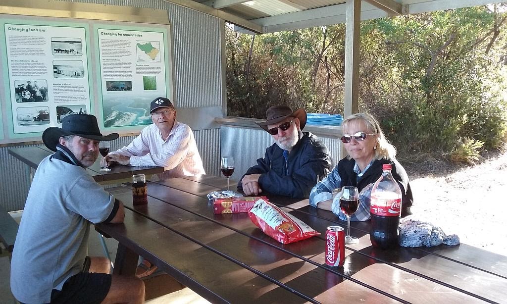
Back at camp, Bruce was waiting patiently for my return. He selected a site and set up his tent. At 1700 we ventured off to the kitchen for the arvo session. John, the camp host for Fanny Cove seen at top of picture:
A pretty good double rainbow appeared above the inlet, but I was let down on the photographic equipment, only having my phone on hand to try to record it:
Bruce and I then went about cooking dinner, and had a few drinks by the ulti. I went to log the cache at Shoal Cape as needing maintenance, but reading the logs, I see a new container has been issued and the cache owner left the old one in place. I still cant understand the philosophy of leaving the old, water logged one still there. Oh well, it now gives me an agenda for tomorrow. I will take Bruce out to Fanny Cove and find the real cache. That should break him in for things to come!
A short travelling day of 100km's.
During the night, showers fell intermittently. At one stage it absolutely bucketed down. I was happy in the fact the ulti repelled all that was thrown at it. Bruce too was relieved his tent didn't spring a leak. Unfortunately, the wind had picked up and a severe weather warning was broadcast. I had lost a pole on the awning during the night, subsequently fixed when I woke. We spent a few hours sheltering in the kitchen. When the weather started to turn, I took Bruce back down to Fanny Cove and Shoal Cape. The ulti was well and truly soaked which was a good thing: it washed the possum piss off the roof from the last trip to Martins Tank:
We took Bruce's Dmax, as he needed to charge his battery due to only having a starter and running a fridge. The Paj remained at camp. I decided to deploy some solar and check out how the dcdc charger works, now I've rewired it to take solar input:
The puddles were certainly bigger than the day before and Bruce, driving a little slower than me, didn't end up with limestone juice running down his door trim.
I'm sure Bruce enjoyed poking around the Moir Homestead and Fanny cove. I then led him to Shoal cape. I had an ulterior motive: to find the new cache. It was alluding Bruce and myself. Going away and coming back to ground zero from many points of the compass, I finally struck success. We then returned to camp and had an easy afternoon. More poles had come down, so I bit the bullet and staked the poles with 500mm sand pegs. The force required to drive them in would be inversely proportional to the force required to get them back out again. But it had to be done.
Some pictures around the point at Fanny Cove:
The severe weather forecast had been downgraded. We dodged a bullet. Tomorrow, we would explore in earnest, weather permitting:
Bruce would wake around the 5am mark, go for a walk, then have to wait around till I arose about 0800. Doing a lot of early starts at work, these days I struggle to get out of bed early when I'm not working. The ritual would then be that I would have a couple of coffee's and contemplate breakfast but pass the opportunity, only to get hungry an hour down the road. Today we planned on making it as far as Masons Bay. Taking both vehicles, we hit the gravel around 1000, which for me was about an average start to the day.
After some discussion from the prior afternoon's session with the caretakers, we headed for Skippy Rock/Margaret Cove. I had given the gps co-ords to the caretakers the day prior, but they failed to find it, instead ending up at Munglinup. I had heard Munglinup, some 35Km's West of where we were stationed, had received record December rainfall over the previous few days. I thought it was a bit wet. The camp sites here at Skippy are little small. More than suitable for tent based camping, only a few would be suitable for my camper. And they all looked quite wet, bearing in mind the rain we just had.
A fairly tame track with a couple of soft sandy sections led you to the Cove. Numerous rocks abound on the shoreline and Bruce keeps asking me which one is Skippy Rock.
On the way out, we turned off for a look at the Torradup Inlet. A pretty little place, well worth throwing a yak in I reckon:
Bruce seemed to be enjoying the sand tracks:
From there we headed West along Springdale Road to Munglinup Beach. A large snake was seen on the road, one of a few we saw this trip. However, the resident snake that lived at our camp kitchen proved to be elusive. A quick look at the facilities and I headed off in search of 2 caches. I don't think Bruce was real happy when the vegetation closed in, but it was only a short section to traverse. Overlooking the western edge of Munglinup Beach, the first cache was found in pretty quick time. Evidence of it being a popular relaxation point was seen:
We then headed off for the Oldfield inlet for the second cache. A sandbar keeping its contents from spilling into the Southern Ocean. A very picturesque little place indeed, also well suited to a yak:
The cache was found easy enough so we pushed on for Starvation Bay.
A couple of nice tent sites here, but the shire was working on the van/camper sites, so its hard to tell if I like it or not. I guess I'll just have to come back someday. Looking for a cache placed near here, I logged my first did not find. Lots of ferreting in coastal scrub to be had. Moving on, we headed for Masons Bay.
Obviously a favourite with the van set, there were a few people camped here. A nice place, but probably not my style. It may do if you moved away from the others though.
Another cache here was logged as a did not find and we headed back for camp. Arriving back to camp at 1645, just in time for our afternoon session.
230Km's of exploration for the day done
Wednesday comes around and the weather is starting to look reasonable for a change. We had decided we would head East today, out to Cape Le Grand NP. As this would be a fair road trip, we got on the road early IE 0945. Well, that was early for me :) When I woke, I noticed the characteristic itchy lump of a tick in my left flank, just to the rear and out of eye shot (figures, doesn't it). I'm sure this was acquired from searching around in the foliage for that elusive bit of tupperware just so I could sign a log. And to make matters worse, I bet I got it on one of those did not finds...Grrrrr. I have had a few ticks in the last couple of years now, all whilst geocaching. A risk one takes I guess.
Bypassing Esperance to the North, I navigated our way to Fisheries Road, saving a few kilometers and time in the process. What ever we could achieve for the day would be dictated by the time it took us to do stuff. I wanted to call into Esperance on the way home for fuel and a chemist. I wanted to try a new tick removal strategy - ether spray - as used for skin tag removal.
From Fisheries Road, we made our way down to Merivale Road and came across the destruction of those fires a couple of weeks back:
From there we entered the National Park. First port of call being Frenchman's Peak. Bruce wanted to climb it, and so did I because there was another cache at the summit. An opportune moment presented itself upon arrival in the carpark - a commercial airline from the East, making its way to Perth, leaving an impressive contrail against the peak:
The climb was certainly energetic. Bruce, being 3Ft shorter than me had an easier time as he had way shorter legs and expended less energy swinging them than the longer arcs mine needed. A nice cool breeze blew which helped with the heat dissipation. Near the summit, Bruce went to investigate a cave entrance. When I came over (eventually I got there - noting I had longer legs to swing) I was blown away with what I saw. The other end was also open ended and presented the most amazing window of the plain below:
Very near the summit, I honed in on the cache. It took me a bit to find, being 10M or so out by my GPS and was well hidden. but I secured a find:
The short hop from the cache to the very top provided the most amazing view:
We spend a little time up here admiring the view. It was an effort to get here, so there was no point wasting that effort. Then came the descent. Hoping against all odds my sandle wouldn't blow from the pressure being placed on it. With a blown sandle, that granite would chew a bare foot in no time. From carpark to summit and return had consumed 2 hours.
We skipped Hellfire Bay and Thistle Cove (we have both been here before anyhow) and made our way to Lucky Bay. The site was a construction zone, a new van/camping park being made. I would hate to camp here when hot, at the time we saw it, there was zero shade to be had.
Then we moved onto the Le grand camp ground for a look. All 15 sites were occupied. It reminded me why Stokes was so much better in my opinion. Larger, cleaner, 2 kitchens and far less people. Apart from a swimming beach on its doorstep and the parks scenery, I don't understand the fascination with Le Grand myself. Again, upon seeing Le Grand camp site, I was stoked. Each to their own I guess. Bruce wanted a swim here, but I convinced him we had to go to another place, 50Km's to the East. A far prettier place and better place to swim. Time starting to slip away, being almost 1400, we had better boogie.
We took the turn into Duke of Orleans Bay and I took Bruce straight to Little Wharton. It has to be one of the most picturesque places in the region. The contrast in colours, just amazing:
Bruce wanted to climb an outcrop for an aerial view of Wharton Beach. As if he hadn't climbed enough today already. You can see the little legs I mentioned earlier half way up the rock face. I stayed behind. Last year I picked off a cache at its summit:
From my vantage point, you got a glimpse of what Wharton had to offer:
We then drove onto the beach, where Bruce had a play in the waves, whilst I investigated the dunes. I found a nice little area, protected from the wind, that could probably be had for 2 vehicles with a swag each. No doubt, not legally.
With Bruce's swim complete, we hit the road for home at 1540. Worryingly, I suspected we would not make the arvo session back at camp. Refuelling in Esperance, I forwent the trip to the chemist. I will deal with the little blighter later. Arriving back into camp at 1800, my fears were realised, so we went straight onto dinner and drinks by the ulti afterwards. Sometimes I think its not a wise choice discussing controversial topics after dinner. Metronet and capital punishment included. That said, we all went to bed happy.
A 400Km day of explorations now completed.
The next morning was out last day on the ground. I had hoped we could get a trip to Israelite Bay in whilst here. To do so from Stokes, would be a huge day. Knowing what the track is like (I fell into a bog hole last year), and the rainfall we had over the previous few days, made the decision a no brainer. We had to head West again. The plan to make Hopetoun, the Fitzgerald River National Park, and Ravensthorpe. A week return from home just isn't long enough down here. A couple of coffee's down and we hit the road at 1000. High tailing it from camp to Masons Bay, the first port of call being Masons Point:
Down at the waters edge, I played with the DSLR trying to get a decent arty farty shot:
With one eye open, albeit covered, we made sure the flying rat didn't drop a bomb on us on the way back to our vehicles:
We followed the coastline around to Hopetoun, looking in at all the beaches in between. No point publishing more pictures of coastal scenery by now, you must be sick of looking at them all. Mt Barren in the Fitzgerald River NP comes into view:
Just outside of Hopetoun, a choo choo train cache was ripe for the picking. A subject close to our hearts, hey Bruce! The old rail workshop ruins provided a nice place for such a hide. The remains of the turntable still evident:
Maintenance pits and rail scrap still evident:
Lots of ash and charcoal littered the surrounding ground. No doubt from the cleaning of the fireboxes.
Here we had to make a decision: head into the Fitzgerald or head to Ravensthorpe. Being as its now 1330, we cant do both. Bruce had developed a crappy headache. The pain visible on his face. His decision making function, barely functioning at all. So I made the call. We will forego the Fitz as its a far longer trip. Up to the Hopetoun lookout, I secured an easy to find cache. Then onto the wind farm for another. The clue didn't make sense, but I gathered the gist. I think something had been replaced, rendering the clue useless. I had a hunch and started the process. Very soon afterwards, my hunch was proven correct. What a clever little hide that one was.
We then moved onto Kundip, site of some ruins (apparently). Whilst we didn't see much in the way of ruins, Whilst looking for yet another cache, I stumbled upon an old shack:
Some bee hives were found a short distance away. Obviously the reason for the shacks existence. The cache bagged, we headed further towards Ravensthorpe. I took Bruce to a look out not far from Ravvy that I visited last year - Mt Desmond. From there we headed into town for the IGA. I hadn't planned on drinking much bourbon this trip, but once I got the taste, I ran out of mixer.
The plan was to be back at camp at 1600. I wanted to deconstruct my awnings before dinner and afterwards get as much packed as I could before departure in the morning. It takes far longer to pack than it does to set up. As it was now 1530 at the IGA, I realised my plans were shot. It was still another hour back to camp. So I suggested to Bruce and his headache we would go to the lookout at the top of the Ravensthorpe Range for a look (and another cache). Bruce passed a rather large snake on the way up. The view was spectacular:

The cache was about 30m over the edge in heavily wooded Banksia. Scratchy stuff indeed. About 10 minutes in, and vigilant in regards to the time of day, I decided in my best non-snake proofed sandles, I would have to call it another DNF. Another day, with proper attire, maybe, but not today. The map showed a track across and down the range which would lead us back to the highway, so I thought, well lets just do it. Having no knowledge of what to expect, it was part of the adventure.
On the descent, more evidence of the funny buggers bred out this way:
What a remarkable piece of country this relatively short drive is. Totally unexpected. I just wished I had more time to explore. I would highly recommend if you are in the area, with time up your sleeve, to go for a drive through here:
Whilst the track didn't actually traverse where my map showed it did, we hit the highway for camp and the last afternoon session (if we could get back in time). Back into camp at 1730, it was stuff the annex, its time for the kitchen. Some other campers had come in today, introducing Garry and Lannette:
Also here (not in shot) were Darryl, his wife and kids. They had a water shortage, and after dinner, I refilled their supply of 40L of water. This helps them by not having to source any in Esperance, and takes 40Kg of weight away from me towing the ulti home. A win, win.for all. We convinced Darryl to join us for a drink back at base camp ulti, once his kids went to bed.
A 350Km day completed:
Darryl left about an hour earlier, and Bruce retired from base camp ulti about 2200. This left me with the task of removing awnings and as much packing as I could do. And yep, those pegs were a cow to remove. I got to bed just after 0000.
To Bruce's surprise I was up at a 0615. To my surprise as well. A coffee on the go, I finished off the pack for the 700Km trip home. Just in time to make Perth for Friday afternoon peak hour.....Joy.
Bruce departed just after 0700 and I was hitched ready to go about 0800. Spending 1/2 an hour chatting to the hostests with the mostest, Ray and Erika, I bid them farewell and started the long solo journey home.
Bruce, I hope I showed you a bit more the country has to offer. Thanks for coming down, the company was great.
Ray and Erika, hopefully we catch up again when you come back to do another stint of camp hosting.
Another wonderful trip complete. So the question that lingers now back at home, am I Stoked or just ticked off? Well I think I'm stoked, cause the scabies cream killed the little blighter, allowing me to pull it out of my side, ready for another geocache infestation in the future (no doubt....Grrrr)
This trip gives me another 6 nights under canvas brining the running tally to 51 for the year. Now to find the time to squeeze one more in and I'll be a happy camper. An average of one night per week for the whole year. Not a bad effort considering I still hold down a full time job.
Trip Stats:
7 days duration
2420Km travelled
323L fuel used
for an average of 13.4L/100Km
cost of fuel $430
Camp fees $60
EDIT: Once back to work, I find I have been blessed with 4 days off over the Christmas period. That should allow me that last night for the target. I'm thinking a night on the Blackwood will be in order as it looks like I will be in Blackwood River country for Christmas. I will add to this last blog entry on my return to ensure the running tally is kept up to date. I will also do a tally on how many Km's I have traversed this year, and the associated costs. It will be a scary exercise I think.
Till then, best of the festive season to you all. Be safe, watch for snakes and be tick free.