So I had 4 1/2 days off, with nothing planned and great weather forecast....What to do then???
With a 4am start at work completed by 1000, on a last minute spur of the moment decision, I decided to pack the car and head out into the wheatbelt. It had been a while and whilst at it, I could knock off a cache or two. By the time I had done some food shopping and had the car packed, it was 1425 Hrs. That should give me a head start on some wheatbelt stuff in the morning. The rough cut plan in my head was to head to Billiburning Rock, somewhere I had visited but not stayed at previously. Making my way North from the Highway at Kellerberrin, a lowering sun on the horizon meant I wasn't going to make Billiburning before dark. So I put plan B into action....Marshall Rock. This was a lot closer. nearing Marshall, A huge full moon was arising, but with time of the essence, I didn't have time for a picture. As it was, it was dark when I arrived there too.
Having had an early start due to work, the night was a pretty quiet, early affair. But I was in the wheatbelt, just South of Bencubbin, ready for the next 4 days of unknown adventure.


With no real plans except maybe pick off a cache or two, it was a late start. I never got underway until midday. It was pretty warm, so I decided to go into Benny for a cool drink and a cache on the way into town. I was having an experimental trip this time around. No fridge. I just packed an icebox. This would be interesting, as I hadn't used an icebox in years. Could I get 5 days usage on ice alone??
Well it was going to be tough. Trying to fit 2 bags of ice into a 50L icebox full of food/drink was tough. In fact, it couldn't be done unless I broke one bag of ice into pieces. Not ideal, cause it melts faster that way, but it had to be done.
I dropped into lake Mcdermott for a look, a large open area is here that one could push into a quick overnighter if needed. I decided Muckinbudin was the plan for today, trying to make Baropin Rocks for the night. A quick stop at Welbungin tennis club was called for....a cache lying in waiting GC5DP35.
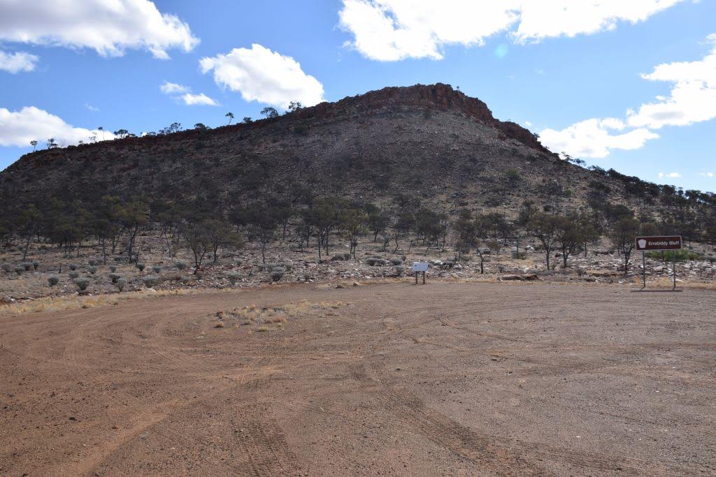
From there it was a short hop to Welbungin Hill. A rather unloved cache (GC5DP4H) needed another signature. I dropped a TB that I had picked up in Dongara and also placed my first pathtag into a cache as an incentive for others to visit. Some 4 months later, and no one has been there since. The view from the top over the surrounding agricultural district was pretty special:


Seeing I was passing "dead men tell no tales" - GC5DP42, I had to go pay homage to poor old Richard. A grave site out in the middle of nowhere.
Making Muckinbudin around 1430, I dropped into the café for some lunch, then headed off to the botanical gardens for another find. I had knocked off another hour of sunlight making these detours, so time was now of the essence to get to camp at a reasonable hour, whilst knocking another couple of caches off.
Making De-Eraning Rock at 1600, I knew things would be tight. I had a fair hike to get to GZ from where the car was parked. The Cache here was a pretty special one, some pretty good aboriginal art is to be found nearby (GC57CTN).
Making my way up the large rock face, I had to find a path through scrub and granite to get to ground Zero. Eventually I got there. It was mid afternoon with temps in the mid 30's when I arrived at GZ. try as I might, I just couldn't find this bloody cache. Approaching from every angle, looking in every crevice and turning over every rock, I must have spent a good 1/2 hour looking for it. Then I read the prior logs. I suspect the co-ords are out a little, and the cache is on top of a large granite sloping rock, some 5M or so above ground. The issue for me being, I reckon I could get up there, but would probably break my neck getting back down. I was solo and a long way from help. It's no place to break a leg, so I had to let it go to the keeper. Next time I might bring some "tools" to help me find it.
The cave at the site was pretty impressive with all it's artwork. So I took some pics and started making my way back to the car.


I had now wasted 1 1/2 hours on this DNF and time was getting on. The original plan was to knock of the sister cache to De-Eranning, but both time and the prior logs told me this wasn't going to happen today. It was time to head for camp. I knocked Baropin on the head and decided to hit Beringbooding rock instead, arriving at 1800.
I quickly got some gear out and got up top of the rock for both the sunset and moonrise. unfortunately, there was an hour and a half between both events, so I just sat up top and waited. I wish I had my DSLR this trip as I may have got a decent moonrise shot with that.


A short 123Km day was done. Arriving back to camp in the dark at 2000, it was time to get some dinner on the go.

Come the morning, after breakfast, I decided to go around the back of the rock to try to find this aboriginal had print I've looked for a few times prior - without success...

A short stroll and I was in familiar country - balancing boulders:

And making my way through the vegetation, I arrived at the site, ready for another investigation for this hand print:

Looking up, looking down, all around the site, again I just couldn't find it. I walked the periphery and just happen to look into a gap in the rocks at a time when the lighting was right - bloody hell, there it was, on the cave wall - the cave I had been in and out of numerous times without seeing it.
Well I'll be buggered. Inside the cave, if you look hard enough, there she was in all its glory 😏. I cant believe I had never found it prior.

Another late start, I got on the road around 1130. With no idea where I was going, I decided to head down to Westonia and maybe check out South of the Highway.....A place I keep meaning to investigate, but never have.
I picked up a cache at Sandleford Rocks (GC2E48A) where I has some lunch in the shade of a tree. Again, it's another hot one today.
Then onto Westonia. What a magic little town this is.
Explore Westonia
I will have to come back one day and spend some time walking around here, but for now, its just enough time to find a niggly nano.....on mechanical equipment. You always know this will be a challenge.....

But I had it in hand pretty quickly:

Mind you, the guardian of the cache was keeping his eye on me:

Another find at the town entrance and it was time for the highway to continue the journey on the South side:

Making a DNF on a cache at Bodallin, I headed East and turned South at Yellowdine. There are a couple of caches down here and I veered off track for one near a salt lake. You have to cross the lake to get to the hide. Unfortunately, I had a bit of water on this track - obviously a storm had rolled through at some stage - and this had me a bit worried about driving across a wet salt lake, solo and unassisted. When the vegetation closed in, that sealed my fate. I turned around. I will leave that one for another day. No point being a hero.
Soon after, I made Mt Palmer and knocked off the cache here (GC6K8XW) then made my way back to the old Mt palmer Hotel for tonight's camp.
What an amazing place. The ruins of the Old hotel is the most significant feature of the area, but with a beer in hand, I went for a short stroll and found the remnants of a now defunct gold mining township.


A more respectable 260Km's for the day done.

Morning dawns and the weather is looking a little sus. I suspect it will burn off during the day. With coffee duties done and a nice omelette to boot, it's time to hit the tracks for Marvel loch at 0900. After 3 days of pretty warm temps, I am needing some ice. I am right for the time being, but I reckon tomorrow I will be out, so best to resupply whilst I can, in Marvel Loch.

All these tracks South of the highway from yellowdine are an unknown entity to me. Knowing the region in general, I fully expect to tracks to either be locked up in a mining lease with no entry allowed, or they will close in with vegetation. but I am pleasantly surprised......for a while anyway.
I turn off a bush track onto a well formed dirt road. It is too well formed for my thinking, I wonder if its a private haul road?
Some 10Km's later, I find the answer....yep, it sure is. No signage whatsoever where I joined this road. It really grates me this mining industry. They can just get access to roads/tracks, put a bit of work in, then claim them as private. Well screw you. Whilst I wont deliberately enter a signed "keep out"place, I have no grudge using a road that I just happen to stumble on in the bush. If the miners take offence to that - well, get over it.

And so I make Marvel Loch. It just appears to be nothing short of a donga village for the local miners. I find the general store - the general store with no ice....Grrrr but the bowser out front is worthy a pic:

Seeing as its only 1000, the pub isn't open either. So on the ice front, I am screwed. At camp last night, I looked at some maps and decided to make my way down to the Holland Track, to exit at Hyden. Always good to have a plan hey! But this means another day without ice. At least the slurry is still ice cold and my food containers aren't leaking.So Another pesky nano is picked off on the way out of town (GC3HZGH)

From there I had to make my way to Mt Holland. Stopping at cockatoo tanks (GC3HZGN) cause it was on the way and there was a log that had to be signed :

However, my main aim was to get down to the site of the Vultee Vengeance (a27-295) aircraft crash site. Not just for the cache, but for the history too.


It makes a riveting read:
reference: yilgarn.wa.gov.au
On Sunday the 27th August 1944 one of the most dramatic events to involve members of
the 15th battalion took place in the far eastern part of the unit’s area.
An RAAF Vultee Vengeance dive bomber went missing on a training flight from Pearce
near Perth. The plane had apparently become lost and run out of fuel. The RAAF
started searching between New Norcia and then Moora without luck. A few days later
a chance conversation between a commercial pilot and Sqd/Ldr Haber, the commanding
officer of No.7 Communications Unit at Pearce, revealed that the former had sighted
what he thought was a tent in the bush east of Narembeen. Next morning a Beaufort bomber
identified a parachute but no sign of life and a large number of soldiers from Northam
were sent for a ground search.
The pilot Warrant Officer J Ingram was located at a remote farmhouse some four days
after the crash and told his story. On realizing that he was nearly out of fuel he had
warned the navigator Flt/Sgt CL King to bale out and went through the necessary roll to
allow him to do so. He then climbed for height and baled out himself. There being no sign
of King he headed west and found the farmhouse after four days during which he had only a
goanna to eat.
A huge effort was now mounted to try and locate King and the aircraft. The wreckage was
finally found by a Tigermoth on the2nd of September in extremely thick and inhospitable
scrub, however this did not deter a search party which included 15th Battalion men,
Cpl M Holtfreter and Pte D Wilkins from setting out to find it. They drove a truck as far
as possible then continued on foot. After they reached a spot five miles beyond the truck
it was arranged that a plane would fly over and drop a smoke bomb on the crash site to mark
it. Holtfreter fired his rifle into a tree well ahead in line with the smoke then went
forward and marked it so that one of the others could take a compass bearing. A further
thirteen miles into the scrub they found the crash site. A large area had been burnt and the
plane’s engine was buried ten feet in the earth and the wreckage strewn over ten acres.
There was no trace of King or his parachute, it was believed that he had been hit by the largetailplane of the Vengeance as he bailed out. After the war, his father travelled from theeastern states and enlisted the help of Holtfreter to make another search for his lost son,but to no avail.
Just getting to the cache 50m in the scrub was bad enough. the site is total devastation. Just small fragments of aircraft alli scattered throughout the bush.
So that was a pretty cool detour.
By 1300, I had made Mt Holland and decided to drive the steep, rocky track to the top for another log signing:


The next 2 hours was hell. I only travelled a mere 23km, it was all stop/start/think and pick a route through very deep puddles and ruts without causing vehicle damage. Very early on I copped a bit hit to the front intercooler bashplate (thank goodness for bash plates). Soon afterwards, I reduced the capacity of my auxiliary fuel tank and broke one of its mounting brackets as my arse end slid into a hole. then to top it off, I dented the left side fender on a tree about 1 1/2" in diameter that I misjudged.


All in all, it left a sour taste for me regarding the Holland track, one that means I wont be back. To me it wasn't fun, it was a chore. It wasn't even technically challenging. It was just a pain in the arse. The worst part was that the track wasn't naturally rough - all this has been caused by vehicle erosion from mud warriors, that feel they have to travel these tracks when wet, and then do what they can do to transfer dirt from the track over their panels. I guess rule 5 means nothing.
It's now 1530 and its looking like I may not even make Hyden tonight - if this crap keeps up. However I made a coms tower and a quick find of another cache (GC2E47Y)
From here the track opened up pretty much and I started to make some progress. Apart from a large rut I had to traverse crosswise. I got some pretty big air time from the front left hand wheel, more than I expected and I near crapped myself when it lifted. but all was good, down she came, and onwards I went to cross the barrier fence:

With the last cache on the Holland crossed off (GCVRR1), I finally made Hyden at 1745. Here I managed to grab a bag of ice. Opening the ice box, the carnage was revealed. The rough bouncing along the Holland had tossed my shit everywhere. The slurry now a mix of punctured dip containers, meat juice and all other delightful things. Great. Consulting wikicamps, I found a place I reckon would be suitable for the night, and made haste to get there before dark. There I had to perform ice box maintenance and try to clean up the juicy concoction that now lined the walls of my box. it was only 316 Km's for the day, but it sure was taxing. I was pretty well stuffed.

Whilst every day had been hot - mid 30's, and the nights had been pretty good, last nights camp certainly wasn't. A cold wind was blowing and I just couldn't escape it. In the end, I said screw it, so at 2000, I just went to bed. Something quite bizarre happened though. I spotted a satellite, heading roughly North East. Nothing bizarre in that, but wait, there's more. It eventually flared out and I immediately spied another roughly at 90 degrees to the first, travelling South West. And when that one flared out, another following the trajectory of the first. As if that wasn't weird enough, a 4th, same as the first also appeared. 4 in a row. I doubt I'll ever see an event like that ever again....
I woke early on the last day and decided I wouldn't bother with breakfast or a coffee, but head into Bruce Rock for a bought breakfast. I also noted my geo tally was now 288. Could get 12 more before home to crack the 300? I wsas now back in civilisation, deep into the middle of the wheatbelt.

So I put a plan in place. I picked up 5 in Bruce rock and one DNF.So it's only 0900 with 7 to go.
Stopping in the old township of Kwolyin, I thought I could grab a couple more. But reading the logs, some walking was involved and I just didn't have the time to pick them off. I needed quicker ones. So a detour to Mt Stirling and I had another one bagged. Mind you, that one wasn't quick either, it had taken me 45 Minutes for the one find (GC11XA0)

Now with 5 to go, I picked off 2 at the pink lake (which wasn't pink) , one being an earth cache and then another 2 in town. I was now at 299.

Merredin was looking good to bag 300. I drove up an appropriate named street, to the top of Cunderdin Hill. A bit of looking around and I had hit my target. 300 Finds. You lil ripper. It wasn't planned before I left, but I made it happen once I realised I was so close.

Time now being 1415, meant I was going to have to fight peak hour traffic across town when I got there. I arrived home at 1730, exhausted but exhilarated at the same time. The largest day of my 5 days on the road with 440Km's driven.
I love trips like this....no plans, just go and see what happens. This is living!

Then, I noted that I finish 2018 with a rather tantalising milestone to achieve in 2019.
I will chalk up 100,000 Km's of trips away since 2011. I've been every where man.....

And fuel usage for 2018 was substantial too:

I have a pathtag in production to mark the milestone. They will be starting to be placed in caches once I hit the target.
Bring on a mighty big 2019.
Trip Stats:
4 nights under canvas
1502km travelled
168L fuel used
trip average of 11.2L/100
cost of fuel $263
camp fees $0 - No camp fee's out here 👍.
Finishing the year off with 42 nights under canvas